|
Author
|
Message
|
|
|
Posted Sun 8 Sep 2019 12:46 PM
|
Group: [0]
Last Active: -
Visits: 0
|
Hi Gordon, a question about the Mournes. Are the hikes difficult? Or only the highest parts of the highest climbs? We found the highest part of the diamond hill loop hike pretty hard, especially because of the strong winds on the top. So we went back down instead of completing the loop
|
|
|
|
|
|
Posted Sun 8 Sep 2019 3:31 PM
|
Group: [0]
Last Active: -
Visits: 0
|
Hi Theo! The difficulty of the climb depends on the route, but I personally found some of the routes through the Mournes quite tough. I am from the Netherlands, and not very used to mountains and hills, so it depends on your own experience and level of fitness. The Walk NI website has a super helpful overview with the different trails and loops in and around the Mourne Mountains, and you can see everything from the route type, to length and level of difficulty. This way you can prepare for your hike, and it also has ratings, tips and comments from other visitors. Let us know if there is anything else you need (in het engels of het nederlands). :)
|
|
|
|
|
|
Posted Sun 8 Sep 2019 9:18 PM
|
Group: [0]
Last Active: -
Visits: 0
|
Hi Melin,
It isn't always necessary to get to the top to get beautiful pictures. Is it also hard to hike the lower parts of the Mourne Mountains? Or just to get to the rocky tops? I know what you mean, Us dutch people aren't used to unflat services ;)
|
|
|
|
|
|
Posted Sun 8 Sep 2019 10:03 PM
|
Group: [0]
Last Active: -
Visits: 0
|
Hi Theo, You can find some very photogenic places along the trails, so it's definitely not necessary to get to the top. ;) I personally found the trails that take you through the lower parts comfortable to follow, and even thought these walks can take a few hours, it wasn't too much. I do recommend good walking shoes, and a bag with water and some snacks for along the way. The path is very well signposted and colour coded, so there isn't any risk or losing your way. :) How long would you like to explore the area for? One of my favourites is Silent Valley, which includes beautiful views of the water reservoir. I've tried all of the routes, and even the black trail was quite doable.
|
|
|
|
|
|
Posted Mon 9 Sep 2019 11:40 AM
|
Group: [0]
Last Active: -
Visits: 0
|
Hi Melin,
Thank you. We will be there for 4 days. What points in Silent Valley do you recommend for landscape photography?
|
|
|
|
|
|
Posted Tue 10 Sep 2019 10:25 AM
|
Group: [0]
Last Active: -
Visits: 0
|
Welcome back, Theo! :) It's great that you have 4 whole days to explore! Are you thinking of spending all those days in or near the Mourne Mountains? The beach at Newcastle is lovely too, with its colourful pebbles, and you get some great views of the coastline and the mountains. As far as the routes through Silent Valley go, most of them take you around the water reservoir, and you can even combine different trails because they're not too long. I personally really like the orange (Reservoir Trail) and blue trail (Challenge Trail) for their views of the reservoir with the mountains in the back.  The green trail (Nature Trail) also has a boardwalk and you can spot a lot of the local wildlife there. You can also see the Mourne Wall that goes along the mountain here, and this should make for some good pictures as well. :)  I'm always here if there is anything else you'd like to know!
|
|
|
|
|
|
Posted Tue 10 Sep 2019 8:41 PM
|
Group: [0]
Last Active: -
Visits: 0
|
Hi, thank you! Yes We will spend 3,5 days in the Mourne Mountains area. I would love to photograph from this place, but I'm guessing thats a difficult climb: 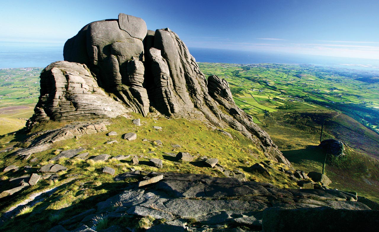 Hen Mountain also seems like a nice place, with a litte pool for nice reflections. Is it easy to get up there? I also marked some other points I think could have nice views: https://goo.gl/maps/FkCC2ReHphPeCi4y7https://goo.gl/maps/MvDBhZNjVrFumqb38https://goo.gl/maps/z6yzLgYMHFL1aGEs5Is there one of the slieves/tops that is easier to get to?
|
|
|
|
|
|
Posted Wed 11 Sep 2019 10:48 AM
|
Group: [0]
Last Active: -
Visits: 0
|
Hi Theo, Getting to the top of the Mourne Mountains can be a strenuous walk indeed, as it's quite steep. Hen Mountain is very nice indeed, and there is a great loop walk through the Hen, Cock and Pigeon Rock Mountains. It has some amazing rock formations and wonderful green views and you can read more about it on this Walk NI page. The points you've marked have quite nice views indeed, and how hard it is to climb all depends on where you would like to start your trail. The first option does require the most climbing. :) If you're looking for a less challenging route, I suggest the Trassey to Bloody Bridge trial. It's a moderate linear walk with sights such as the Mourne Wall, the Castles, Slieve Commedagh and Slieve Donard. I, and I'm sure our other members as well, can't wait to see all of the beautiful pictures from your trip, so please feel free to share all of your upcoming adventures here. When are you planning on visiting?
|
|
|
|
|
|
Posted Sat 14 Sep 2019 8:43 PM
|
Group: [0]
Last Active: -
Visits: 0
|
Thanks very much, Are there any good maps with the trails of the Mourne Mountains?
Tomorrow, we will be driving from Portrush via the causeway coastal route to Mayobridge, near the Mourne Mountains, where we will be staying until thursday, when we fly back. We will do a daytrip to Belfast and explore the mountain area and maybe Tollymore Forest as well.
We've started our trip at Galway, on september 3rd (We flew to Dublin, and rented a car at the airport). We stayed for 3 nights in Oughterard and we've been to the Burren, Galway city, Dunguaire castle, Connemara, did almost the whole Diamond Hill Loop (it was to windy up top), Sky Road. Then we stayed for 3 nights in Ardara, went to Downpatrick Head, Ben Bulben, Slieve League, Assaranca waterfall, Glengesh Pass, Donegal town, Crohy Head, Glenveagh Park, Mount Errigal. Then we went up to Letterkenny for 3 nights, exploring Fanad and Inishowen Peninsula with Fanad head Lighthouse, Murder Hole Beach, Letterkenny town, Ballymastocker Beach, Five finger strand, Malin Head, Dunree Head, Derry, Glenevin Waterfall, Tullagh Bay Beach, Carrickabraghy castle. And now we are in Portrush, explored the Dark Hedges, Carrick a Rede, Giants Causeway, Mussenden Temple, Dunluce Castle, Whiterocks Beach and Kinbane Castle.
Hoping for nice weather for photography and hiking in the Mourne Mountains, although the forecasts aren't that good. I would love to share some of my photography when I'm back. Sometimes the weather and sky were magnificent, but we had a lot of grey and dark weather as well, so not always the opportunity for good photo's.
This is our second time in Ireland by the way, 4 years ago we explored the southern half of the country, especially the (south)west-coast.
|
|
|
|
|
|
Posted Mon 16 Sep 2019 9:14 AM
|
Island of Ireland
Posts: 797
Group: Community Moderator
Last Active: 8 hours ago
Visits: 13.9K
|
Wow, you certainly have managed to see some excellent places so far and we can't wait to see all the magnificent photos from your time with us! Ordnance Survey Ireland has a series of excellent maps on the whole of the island of Ireland, you should be able to find them in local stores and online. Another great resource online is Irish Trails, you can select walks and routes by county which is always a handy way to find something in any location. The weather is sometimes hit and miss but hopefully it will stay nice for a few spectacular photos.
|
|
|
|